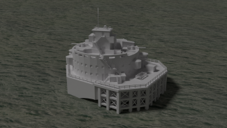
Bull Sand Fort is one of my personal favourite architectural gems (which is unusual as I have a leaning towards gothic architecture) and it has a very evocative and mysterious presence in the Humber Estuary. It sits on a sand bank near Spurn Point (see my 3D model of the lighthouse) and the smaller island fort of Haile Sand.

Bull Sand Fort was built during the First World War to protect the ports located further up the estuary and was officially completed in December 1919.
Both of the forts were often under attack from aircraft and submarines. As of 1987 the fort was given Grade II listed status.
This artistic representation of the fort depicts as it was during the period of the Second World War, with the enhanced gun emplacements at roof level.
The fort contained accommodation for a garrison of 200 including sleeping quarters, stores for beer and coal, a kitchen and boiler rooms.
Although not necessarily true to life of the real Humber Estuary, I modelled the water with some level of translucency so the submerged features of the fort can be seen. The structure was modelled using photographs as a reference and the creation of texture UV maps in Adobe Photoshop. Original plans of the fort dating from 1917 can be consulted in the East Riding Archives, archive reference DDX1200/3/2 and are really interesting historical documents.
For a more in-depth history of this fascinating structure please see this informative account from the Island of Hope website.
